I love the picture of the lion laying peacefully with a lamb … not attacking it and devouring it. There is coming a time when this will be a reality. I love cats and I am looking forward to the time when I can play and interact with big cats just like I can with our domestic cats we have as pets. All of that has nothing to do with this post. I am writing about riding and the weather. March came in like a lamb, but went out like a lion. And now that we have moved into April it is still rather nasty weather so far … not pleasant weather for riding. Hopefully this will change soon. However, we have another weather related saying … April showers bring May flowers. We are seeing a fair amount of rain so far and all of our local rivers are flooded and the trails alongside of them are closed because of flooding. All of that brings up yet another saying … “Rain, rain, go away. Come again another day.” Yep, if it would just stop raining and warm up so that we have nice riding weather. Actually it has stopped raining for today. Tomorrow rain is back in the forecast as are some other days. Rain is predicted for 7 of the next 10 days. Oh well, it is what it is and we get what we get. Meanwhile I think I will just wait until God changes the animal kingdom (Isaiah 11:6 and other scriptures) and I can play with those big cats. A very few are able to do so now …
KEEP ON TRIKIN’
You are invited to come join the Tadpole Rider Facebook Group. Please note that in order to join you must first answer the three membership vetting questions.
Why wish upon a star when you can talk to the One (Jesus) Who created them?
TODAY IS THE OLDEST YOU’VE EVER BEEN, YET THE YOUNGEST YOU’LL EVER BE SO – ENJOY THIS DAY WHILE IT LASTS FOR THIS IS A DAY THE LORD HAS MADE! REJOICE AND BE GLAD IN IT!
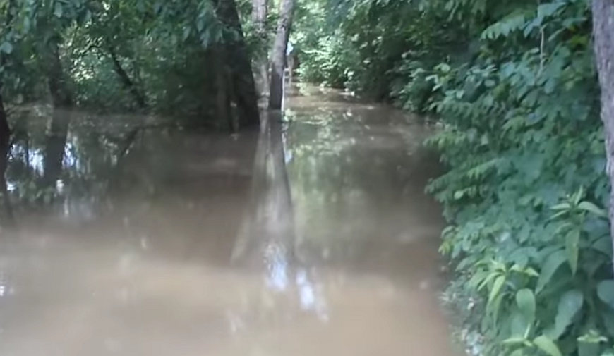
Flooded over trails is something that happens all too often. All it takes is one day of rain and some of our local trails close for weeks sometimes. This is something I have written about several times before so I won’t repeat myself here. I will simply provide a link to a past article I wrote about it.
I am amazed that one of our local rivers rarely ever rises up under a major highway flooding over the trail which goes under the highway. Looking at the river here one would think it would readily flood over. Yet I have only seen it flooded over a couple of times. And this river has flooded over elsewhere at other locations and doesn’t even rise any here oftentimes.
It is a mystery to me, but I am glad about it as I can still ride this trail when others are closed due to flooding. I may have to take alternate detours elsewhere but most of the trail is rideable when others are not.
Dealing with all too frequent flooding and trail closures gets old quick. Never the less, I am thankful I still have other trails to ride that usually don’t flood. And if worse comes to worse there are always streets and roads to ride … as hellacious as they are. I am talking about pot holes. I don’t know how many thousands of dollars I have spent repairing my trike from damage Fort Wayne streets have caused. The heavier duty BMX wheels I have now are holding up much better than the stock Catrike wheels did. Still I hate hitting pot holes and there are lots of them and I can’t usually avoid them. With the Catrike wheels I was constantly breaking spokes … I mean dozens of them. I think I have had only one broken spoke since I got the BMX wheels. I have put a lot of money into my trike over the years, but it is serving me well and holding up well with the components I now have on it. I just wish I had made the changes sooner rather than keeping it stock for so long.
In addition to the trail closures due to flooding there are also several utility, construction, tree removal, and bridge closures all going on at the same time in many different locations. As they say “when it rains it pours”. And as they say … “you’ll have that!” And I can vouch for it … we got it.
You are invited to come join the Tadpole Rider Facebook Group. Please note that in order to join you must first answer the two membership vetting questions and agree to comply with the group rules.
It is raining and the rivers are rising expected to go way above flood stage. That means that most of our local trails will be flooded over and closed. Boo Hoo! Probably only one trail will be unaffected and will remain open (hopefully). It always bums me out. It only takes one day of rain to close a trail but then it takes several days sometimes weeks before it reopens. This usually happens at least a half a dozen times a year. Here is a video I filmed almost 4 years ago of trail flooding.
Even small creeks and ditches can cause major problems and close trails.
The flooding shown in the beginning of this video above no longer occurs. The street has been entirely reconstructed and raised up so flooding can’t happen there anymore. And there is a new bridge over the creek. It is a great improvement.
One of the things I am most amazed with is how deep the flood water can get. On one trail, the Maumee Pathway, there is an area that floods over where the water level is higher than I can reach while standing on the trail. In the picture below I have drawn a yellow line about where the trail is under the flood water. The red X is about where the water level is well over my head. I am short so I can only reach about 7 feet up. My guess is based on what I see on the trees the flooding gets about 9 feet above the trail. It doesn’t seem possible. BTW, in the picture below the Maumee River is on the other side of the trees. That is not a river you are looking at in the picture. It is flood water across the trail and over onto an adjacent farmer’s field. The first picture below shows the trail and the farmer’s field.
The next picture below shows the same area flooded over. The trail is marked in yellow and the red x is where it floods so deep.
Below is a photo of that area of the trail that floods over so deep. You can see the river on the far left and the farmer’s field on the right.
In the video below you can see this area and all the flood water that covers several acres of farm fields on both sides of the road. It takes a long time for all of this water to disappear.
Yeah, it really bums me out when all this flooding occurs. It would not be so bad if it would go away quickly and the trails would reopen. But every time it floods the trails get covered with clay river silt which makes for a very muddy and slippery mess. All of that has to be removed which is no easy job.
Sometimes gates have been closed so trail users can know that the trail is closed. But sometimes there is no way of knowing flooding has occurred until you come to it riding along the trail.
I learned the hard way not to attempt to ride thru flood water. One can’t tell how deep it is and attempting to ride thru it can result in bad things happening. I won’t elaborate on that other than to say that cold water on a winter day is no fun to ride thru when it is a foot deep or more. Brrrrr!
Well, despite flooding and trail closures I am going to do my best to …
Keep On Trikin’
It may result in having to ride on streets and roads more than I usually do. It won’t be the first time.
There won’t be any rain or flooding in heaven. There probably won’t be any tadpole trikes either. That’s okay, though. I am sure what ever the Lord has it will be great … far better than anything we have here on earth. Are you ready for the journey ahead? The way has been provided and made clear. It all starts by accepting God’s free gift.
Flooding – St. Marys Pathway between Sherman and Main St
Flooding – St. Marys Pathway in Swinney Park West in the low spot between Jefferson Bridge and the parking lot
Flooding – St. Marys Pathway between W. Swinney Park and Taylor St Bridge
Flooding – St. Marys Pathway between the Fairfield Ave Trailhead and Tillman/Calhoun
Flooding – Maumee Pathway between Pemberton and Maplecrest Ext
Flooding – Maumee Pathway the N. River Rd Trailhead and Rose Ave in New Haven
**********
There is no mention of the Towpath Trail but I bet it is flooded over also. They have to physically go there to check it out unless someone reports it to them.

 I love the picture of the lion laying peacefully with a lamb … not attacking it and devouring it. There is coming a time when this will be a reality. I love cats and I am looking forward to the time when I can play and interact with big cats just like I can with our domestic cats we have as pets. All of that has nothing to do with this post. I am writing about riding and the weather. March came in like a lamb, but went out like a lion. And now that we have moved into April it is still rather nasty weather so far … not pleasant weather for riding. Hopefully this will change soon. However, we have another weather related saying … April showers bring May flowers. We are seeing a fair amount of rain so far and all of our local rivers are flooded and the trails alongside of them are closed because of flooding. All of that brings up yet another saying … “Rain, rain, go away. Come again another day.” Yep, if it would just stop raining and warm up so that we have nice riding weather. Actually it has stopped raining for today. Tomorrow rain is back in the forecast as are some other days. Rain is predicted for 7 of the next 10 days. Oh well, it is what it is and we get what we get. Meanwhile I think I will just wait until God changes the animal kingdom (Isaiah 11:6 and other scriptures) and I can play with those big cats. A very few are able to do so now …