This is a trail I see mentioned often on social media. The Virginia Creeper is a 34 mile long rail trail located in southwest Virginia. It runs from Abingdon on the west end to near Whitetop Station near the North Carolina State Line on the east end. The town of Damascus in at the half way point. Bike rental and shuttle service is available in Damascus.
This trail got its name from the fact that railroad locomotives had to creep along at a slow speed as they climbed the steep grade. Most railroad tracks are built with a maximum of a 2 % grade, but this corridor has some 7 % grade which is difficult for a locomotive to climb.
KEEP ON TRIKIN’
You are invited to come join the Tadpole Rider Facebook Group. Please note that in order to join you must first answer the three membership vetting questions.
Why wish upon a star when you can talk to the One (Jesus) Who created them?
TODAY IS THE OLDEST YOU’VE EVER BEEN, YET THE YOUNGEST YOU’LL EVER BE SO – ENJOY THIS DAY WHILE IT LASTS FOR THIS IS A DAY THE LORD HAS MADE! REJOICE AND BE GLAD IN IT!
It was a grand day when someone came up with the idea of converting former railroad corridors into bike trails. Rail Trails are all over the place and very much used by many people. Here where I live in Fort Wayne, Indiana we only have one rail trail so far, the Pufferbelly Trail, which immediately became one of my favorite trails. It is part of a greater trail of 91 miles in length called the Poka-Bache State Visionary Trail. Trail planning and constructionis very much alive in Indiana as it is in many other States.
I just stated above that Fort Wayne has only one rail trail. That is not true. I forgot about the Fish Line Trail which at this time is only a mile long in our area. Further north starting in Kendallville, Indiana it has been constructed on further north. Eventually it is suppose to run clear to Grand Rapids, Michigan as well as further south of Fort Wayne. That will be a pretty long rail trail … more than 180 miles.
I have not traveled around much riding various trails like some people have. I feel fortunate to have been able to ride on the trails I have been on which include: Angola Trail, Auburn Trail, Decatur Rivergreenway, Pumpkinvine Nature Trail, Nickel Plate Trail, Panhandle Trail, Cardinal Greenway, and the Monon Trail. In Ohio I have ridden on the southernmost section of the Little Miami Scenic Trail. That is about it. Of course, I have ridden extensively on all of the Fort Wayne Trails … some 120,000 miles worth.
If virtual riding counts I have ridden several other trails. It is not likely I will ever actually get to ride them, but with Google’s help I have checked them out already and become somewhat familiar with some of them, particularly the Withlacoochee State Trail in Florida.
As I said, some people are fortunate enough to travel around and ride on many different trails. Here is a video by a fellow cyclist who has done just that and this is his top ten list of rail trails in the U.S. …
KEEP ON TRIKIN’
You are invited to come join the Tadpole Rider Facebook Group. Please note that in order to join you must first answer the three membership vetting questions.
Why wish upon a star when you can talk to the One (Jesus) Who created them?
TODAY IS THE OLDEST YOU’VE EVER BEEN, YET THE YOUNGEST YOU’LL EVER BE SO – ENJOY THIS DAY WHILE IT LASTS FOR THIS IS A DAY THE LORD HAS MADE! REJOICE AND BE GLAD IN IT!
With nasty winter weather outside I find myself cooped up in the house. I was just looking at paved bike trails in the greater Atlanta, Georgia area. I used to live in Gwinnett County to the northeast side of Atlanta. At that time there was no place to ride a bicycle. Now there are a few trails here and there, but the problem is there is very little connectivity between the trails and one would have to haul the trike to a trailhead to ride. Further complicating things is that most of the trails are very short and not worth the hassle driving there to ride on them. There are some longer ones, but they are much farther away. Driving thru the heavy Atlanta traffic just is not attractive to me. It was bad enough when I was younger but now that I am much older it difinitely is not something I want to do. Connectivity is a big problem. I don’t know if this scenario will ever change or not. Oh well, I don’t live there anymore so it is really not a concern.
Here where I live now in Fort Wayne, Indiana we have a lot of paved bike trails and many of them are connected together. Also I can ride from home to get to them so I don’t haul my trike anywhere. That makes it nice. And more trails are being built continually. That make it really nice as I am not one to travel about checking out other trails around the nation.
I am 77 years old now so most of my life is behind me. I have no idea how many more years of trike riding I have left. I may never get to ride all the new trails that are planned for my area. One trail I am anxiously awaiting the completion of is the Poka-Bache State Visionary Trail which is a 91 mile long rail trail in northeastern Indiana. It runs thru Fort Wayne so I can easily and readily access it. Fort Wayne and Allen County has almost all of their section they are responsible for done. It is about 50 miles from Fort Wayne to Pokagon State Park up near the Michigan State Line so riding there and back would be a very long ride for this old man. I don’t know if I will ever be able to do it or not. It would be easier for me to try riding south instead of north. That is a little bit shorter distance … about 41 miles making a round trip of about 82 miles. That is still a lot to tackle anymore. Anyway, my plan is to …
KEEP ON TRIKIN’
You are invited to come join the Tadpole Rider Facebook Group. Please note that in order to join you must first answer the three membership vetting questions.
Why wish upon a star when you can talk to the One (Jesus) Who created them?
TODAY IS THE OLDEST YOU’VE EVER BEEN, YET THE YOUNGEST YOU’LL EVER BE SO – ENJOY THIS DAY WHILE IT LASTS FOR THIS IS A DAY THE LORD HAS MADE! REJOICE AND BE GLAD IN IT!
Years ago my wife and I used to live down in the Atlanta Georgia suburbs. There were not many places one could safely walk or ride a bike back then. Since we moved back to Indiana that has changed considerably although I still would not be able to ride from home safely like I do here in Indiana. I was not a fan of driving around in the Atlanta area but I did so because my work required it. And from what I have heard it has only gotten worse since we left. My point is even though they now have paved bike trails available I would have to haul my trike in my truck to get to them to ride. The exception to that would be to buy a home near a trail … one that connects to other trails. The Silver Comet Trail is a popular trail and considerably long and flat making it attractive. And my understanding is much of it is well shaded which would be a big plus for riding in HOTLANATA. Here is a video of riding on the trail on recumbent trikes.
I love this video below. These riders look like they are really enjoying themselves. I find it very inviting. I would love to be there riding with them.
The Silver Comet Trail is a 61.5 mile long rail trail in Georgia running east and west. It crosses over into Alabama where it joins up with the Chief Ladiga Trail which goes another 33 miles. And there is also a 6.5 mile long extension to Anniston, AL.
Eventually Georgia and Alabama will connect to neighboring states and become part of an extensive interconnected national trail network. There are lots of YouTube videos about the Silver Comet Trail available.
I noticed that there were a lot of tadpole trikes being ridden on the trail. I don’t know if that is normal for this trail but if it is I would really like that. I am not a fan of heat and humidity so I would be miserable thru the summer months. They don’t call it HOTLANTA for nothing.
KEEP ON TRIKIN’
You are invited to come join the Tadpole Rider Facebook Group. Please note that in order to join you must first answer the three membership vetting questions.
Why wish upon a star when you can talk to the One (Jesus) Who created them?
TODAY IS THE OLDEST YOU’VE EVER BEEN, YET THE YOUNGEST YOU’LL EVER BE SO – ENJOY THIS DAY WHILE IT LASTS FOR THIS IS A DAY THE LORD HAS MADE! REJOICE AND BE GLAD IN IT!
As the name implies it is for those who like riding their trikes and bikes on trails. And again as the name implies I am talking about trails anywhere and everywhere. So far there are only 9 members counting myself … so I would love to see the membership grow.
Right now it is an OPEN group and I hope to keep it that way as long as possible. I have made all the other groups I have PRIVATE in order to keep control of them. I fully expect to have to do the same with this group eventually. Facebook users are constantly posting about and asking about trails they ride or want information about. They do this on several other existing groups. Why not have and use a group designed for trails and information concerning them? It makes sense to me. I hope you agree and will use it. So long as the group remains OPEN it won’t be necessary to join the group in order to view it or even post or comment on it. But I sure hope you do decide to join it. If ever I have to change it to a PRIVATE group only members will be able to view it and post and comment on it.
Trail Riders Intnl. is a group for those who ride a pedal powered cycle on trails. Its purpose is to share with others concerning existing and future trails. Please be sure to mention the name and location of trails. Other information such as how long the trail is, what its surface is, whether it is a rail trail or not, whether it is maintained or not, how busy the trail is, whether it connects to other trails, whether e-motors are allowed or not, etc. would be helpful and appreciated. Posts must be about bike trails. Selling of merchandise is not permitted. Pictures, videos and links about trails are also greatly appreciated.
Please note — this group is not for motorcyclists, horse riders, etc. It is strictly for pedal powered bikes and trikes. They can be with e-motor assist.
I think this FB Group could be a valuable resource to all of us but it will take our participation in it to make it that. I am doing all I know to do on my part to make it successful and will continue to do so.
Here are a few links to handy websites concerning trails:
TODAY IS THE OLDEST YOU’VE EVER BEEN, YET THE YOUNGEST YOU’LL EVER BE SO – ENJOY THIS DAY WHILE IT LASTS.
You are invited to come join the Tadpole Rider Facebook Group. Please note that in order to join you must first answer the three membership vetting questions.
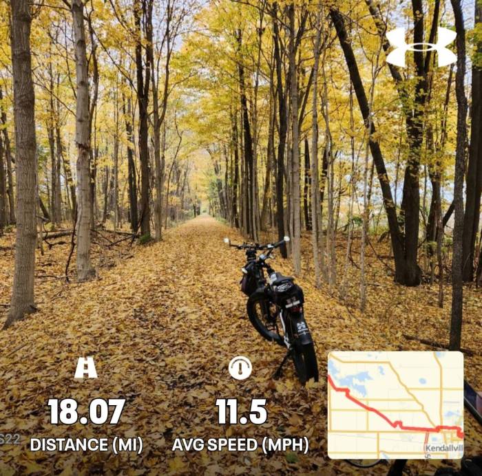
I just discovered a new trail part of which is already in existence. It will eventuallly come to my area … Fort Wayne, Indiana. Right now what exists starts in the northwest side of Kendallville , IN. and goes northwest to near Sylvan Lake near Rome City, IN. There is a one mile long portion of this trail which has been built here in Fort Wayne. I rode it a couple of days ago.
BTW, if you aren’t already a member of TrailLink.com I highly recommend them as a great resource concerning trails. It may very well be the best I have found. There is no cost to join TrailLink.
Here is the start of the trail in NW Kendallville …
I have been on North Angling Road many times when I was younger. There use to be a gravel pit just off of this road I went to along with a couple of friends where we would ride our motorcycles back in there. We had a blast until they closed it off to the public. These many years later I just took a look on Google satellite image of the area and I can’t even see any evidence of a gravel pit ever being there. But back to the Fish Line Trail … most of the trail utilizes the historic railroad corridor that once carried trains for the Grand Rapids and Indiana Railroad. The trail is just over 18 miles long at this time. It is my understanding that it will eventually be built south to Fort Wayne as we as further north. Trail Link reports that the trail’s current northern end lies in Rome City on Lions Drive, just at the edge of the open space of Gaff Park. The trail requires another brief on-road connection via County Roads 450 E and 800 N, before resuming southeast on the former railroad corridor all the way into the outskirts of Kendallville. The Fishing Line Trail, located in Northwest Fort Wayne, is named for its history as a railroad corridor. Formerly the Grand Rapids & Indiana Railroad, residents in Fort Wayne used to hop on the trains and head north to Michigan to fish. So now you know … that is where the name comes from.
Right now the Fort Wayne portion of the Fish Line Trail runs for only one mile in between Washington Center Road and Cook Road (red line in image below). This is west of Lima Road. Eventually it should connect to the existing trail in NW Kendallville. Of course Allen County will only take the trail north to the county line and Noble County will bring the trail south to the county line where the two will meet up. I rode Fort Wayne’s section today. It is a nice trail. Our city’s Trail Manager told me that the Fish Line Trail is a “regional trail” which will eventually go north to Grand Rapids, Michigan. That would be a long ride. In other words, it won’t stop in Wolcottville. The trail manager said that Fort Wayne may have some problems trying to take the Fish Line Trail north of Dupont Road as much of the area is already developed and privately owned. She said that they may have to use some other trails to get further north before they can take it to meet up with Noble County’s trail. By the way, she also said that she thinks Noble County has built about 12 miles of the Fish Line Trail so far, but some cyclists show it is just over 18 miles long. Here is a map of the one mile of the Fort Wayne Fish Line Trail that has been built thus far …
That reminds me of some humor I came across as a teenager. When the railroad was being built across the United States the eastern portion was to meet up with the western portion. A golden spike was to be used to connect the rails together. Here is the humor in how the tracks met up together at Promontory Point …
The existing trail in Noble County is well maintained by volunteers but it isn’t plowed off in the winter time. The trail is almost all asphalt paved with the exception of the very northernmost section … from the area of the Gene Stratton Porter Memorial Home to Kendallville. Of course, it is possible that by now it is all paved.
The next 3 pictures are all taken on Fort Wayne’s one mile section of trail …
Crossing Ludwig Road …
North end of trail at Cook Road …
Noble County Trails has plans to expand Fish Line Trail north to Wolcottville, IN and south to Avilla, Ind. Avilla is getting closer to me but it is still quite a distance from the Allen County line where I am at. I would be very surprised if much of anything happens in Allen County as far as Fish Line Trail expansion to the county line. It is not even listed among the many trail development projects which I receive monthly updates on. I doubt if it will ever get done in my lifetime or at least in the time I have left I will continue to ride. It would be great if it all got built fairly soon as it would make for a great trail to hop on and ride some distance.
Lagrange County Trails (the next county north of Noble County) also has trail building plans. I don’t think they have any immediate plans to continue the Fish Line Trail further north. Instead I think their future trail will have another name but may connect to the Fish Line Trail. The proposed 17 mile Hawpatch Trail, which will stretch west to east from Millersburg to Topeka, and from Topeka to Wolcottville is getting closer to its beginning. As I stated above Noble County is suppose to extend the Fish Line Trail further north to Wolcottville. The image below shows the approximate route of the Hawpatch Trail.
This is a poor quality video for sure, but it is the first and only one I could find when I first looked …
Definitely parts of it look like a fun ride with several sharp turns. As you can see in the video there are at least two times the trail incorporates the use of county roads as part of the trail.
Noble County Trails shows on their website — Benefits of Trails: When a trail is constructed, people use the path for many purposes. The multiple uses are one reason why trails are so successful and appeal to so many people. Trail benefits include: Improved Health … the Indiana Trails Study, which surveyed trail users on six different trails in Indiana, found that in all locations, over 70 percent of trail users reported that they were getting more exercise as a direct result of the trail. (Indiana Trails Study, Eppley Institute for Parks and Public Lands, Indiana University, November 2011), Safe Transportation, Economic Boost … The bicycle industry is estimated to support 1.1 million jobs, generate nearly $18 billion in federal, state, and local taxes, and contribute $133 billion annually to the U.S. economy. (The Active Outdoor Recreation Economy … by the Outdoor Industry Foundation, 2006), and Better Quality of Life.
I can’t argue against any of that! I am an avid trail supporter and trail user. I love riding on trails. Hey, ENJOY THE RIDE!
HERE is an online map showing existing, planned and proposed trails in Fort Wayne and Allen County, Indiana.
TODAY IS THE OLDEST YOU’VE EVER BEEN, YET THE YOUNGEST YOU’LL EVER BE SO – ENJOY THIS DAY WHILE IT LASTS.
You are invited to come join the Tadpole Rider Facebook Group. Please note that in order to join you must first answer the three membership vetting questions.
The Pumpkinvine Nature Trail is a rail trail between Goshen and Shipshewana, Indiana. It is about 17.6 miles long. It has a 15 mph speed limit on it. Class 1 and Class 2 e-bikes are allowed on it. Class 3 are not allowed. I have ridden it about 3 times. I didn’t care much for the section between Goshen and Middlebury. I found it rather boring as many rail trails are. It was pretty straight and no shade. I much preferred the section between Middlebury and Shipshewana.
There is a nice bicycle shop in Middlebury quite close to the trail. They also sell and service tadpole trikes. It is called Pumpkinvine Cyclery. They sell Catrike, Trident and Azub recumbent tadpole trikes. In the image below taken from the trail you can see the bike shop just straight across the highway.
Pumpkinvine Cyclery is right across Indiana Highway 13 from the trail. There is a sidewalk all along the highway on the west side so one could exit the trail at York Drive onto the sidewalk and ride to the shop without having to cross the highway in front of the store … which would be a little safer. On the map below the side walk is shown in black.
The Pumpkinvine Nature Trail also connects to the MapleHeart Trail which runs alongside of a highway going from Goshen to Elkhart, Indiana … a 5 mile distance.
There is a great FACEBOOK page for the Pumpkinvine Nature Trail.
BTW, I have failed to mention that this trail is in Amish country so expect to see Amish people out and about. Be careful around their buggies, wagons and horse pulled farm equipment. Horses spook easily. The sound of flapping flags can spook them. It is best to slow way down or even stop and allow them to pass you. There are often Amish people bicycling on the trail. Shipshewana is definitely a rather unique town with various Amish stores, restaurants and a flea market. The trail used to stop a short distance outside of Shipshewana, but I understand that since the last time I was there riding the trail they have extended it on into town.
1.75 miles of the trail north of Goshen is packed crushed limestone. The rest is all paved with asphalt. 1/2 mile of the trail utilizes a county road as part of the trail. That is east of Middlebury if my memory serves me right. It is low traffic so there should not be any concern. The local motorists are quite accustomed to sharing the road with trail users.
TODAY IS THE OLDEST YOU’VE EVER BEEN, YET THE YOUNGEST YOU’LL EVER BE SO – ENJOY THIS DAY WHILE IT LASTS.
You are invited to come join the Tadpole Rider Facebook Group. Please note that in order to join you must first answer the three membership vetting questions.
The NIRCC (Northeastern Indiana Regional Coordinating Council) has a website with some useful information. I just discovered in thanks to our local trails senior manager who is in charge of trail planning and construction for Fort Wayne and Allen County. She sent me a link to the NIRCC website as I had emailed her asking a question about the status of the Poka-Bache State Visionary Trail. Allen County is currently working on the last section to be constructed in the north end of the county. Then Allen County will be thru with their portion of the trail other than a connecting section between the north section and the southern section which is scheduled to be built in 2024. BTW, the Poka-Bache Trail is called the Pufferbelly Trail in Allen County.
I was hoping the two counties north of us will have their sections they are responsible for completed near the same time Allen County will have their section completed, but our trail manager said it will probably be another 15 years before the Poka-Bache Trail is completed. I doubt if I will still be alive in 15 years much less able to ride at all let alone tackle the 81 mile long trail. On the map below sections that still need to be constructed are shown in yellow so you can see much remains to be done. … about 50 %.
Even Allen County has a southern section that still needs to be built. Allen County has constructed far more of the trail than any of the other counties involved. Dekalb County has done very little so far. The existing trail they have shown in red between Auburn and Waterloo has been in existence for a very long time … since 1976, some 47 years ago. In fact, it is referred to as Indiana’s first rail trail. I have ridden it 2 or 3 times. I have written one article on the Poka-Bache Trail in Auburn and Dekalb County. The 7 mile long section in Angola to the north was completed in 2009. I have ridden it once, but it was only in Angola and out to the north a little ways them. It did not go to Pokagon State Park then. I don’t know when they added that as I had never heard about it being built.
Anyway, this website provides information on each individual county and town/city involved in the construction of the Poka-Bache Trail as well as other trails and bike routes in N E Indiana.
You are invited to come join the Tadpole Rider Facebook Group. Please note that in order to join you must first answer the three membership vetting questions.
Syllvia Halpern has completed riding on the Katy trail on her current 9000 mile 10 month long journey across the U.S. and back to the West coast. She has a blog among her various media resources. HERE is her writeup with pictures of riding on the Katy Trail.
HERE is an article with the details of her 9000 mile 10 month long journey. HERE is Sylvia’s YouTube Channel. I noticed that at the time I composed this her videos are not up to date. She is now in Illinois but her most recent video has har just entering Oklahoma. I guess more recent videos are published but they are not yet listed for some reason. Here is one of riding to the Katy Trail …
You are invited to come join the Tadpole Rider Facebook Group. Please note that in order to join you must first answer the three membership vetting questions.
Here where I live in Fort Wayne, Indiana we have a trail which at this time lacks a connecting section between what is built to the south and what is built to the north. I am talking about the Pufferbelly Trail which I have written about before. The section which needs to be built to connect these existing sections must cross a busy six lane highway (Coliseum Blvd). Obviously the very safest way to accomplish this is to build a bridge which goes up and over the highway. That is the eventual plan but that costs big bucks which the city does not have at this time. So for now the plan is to have a street level crossing. I have to admit that has me concerned. We have already had two trail users killed on this trail on the north section. Both were hit by cars as they attempted to cross roads in the crosswalks. And these were only 2 lane roads and not heavy traffic like Coliseum Blvd. In both fatalities the car drivers were at fault.
On the same trail we have a bridge over another often busy street (West State Blvd). It is really nice and is great to use.
Coliseum Blvd. already has several traffic lights and one more is not going to be welcome by motorists. Below is a map of the section of the Pufferbelly Trail which is suppose to be built next year. Coliseum Blvd. was originally built as a by-pass but it didn’t last long before it was all built up and very congested. In the aggravation and frustration that followed it became known as the 7 mile long parking lot.
On the map below the section which needs to be built yet is shown in orange. The sections shown in red are already built and in use.
In the satellite image below it shows where the crossing will be located. It shows that there will be a “refuge island” out in the middle of Coliseum Blvd. Personally I would like to see some sort of gates come down stopping traffic so that they could not get to trail users without crashing thru the gates.
All of this plan has changed. Please see the UPDATE further below.
Here is a street view of the area on Coliseum Blvd. where the Pufferbelly Trail will cross. As you can see there are 6 lanes of traffic. The one side doesn’t appear to be very busy as traffic behind the camera is stopped by a traffic light when the picture was taken.
At another busy road (Dupont Rd.) they built the trail going under the road which is even nicer than a bridge going over a road. They were able to do this while rebuilding the road. I think the road project paid for it and a good chunk of the money came from the State of Indiana.
Although I am somewhat terrified at the thought of crossing this busy road (Coliseum Blvd.) I am looking forward to having this connecting link completed so trail users have a way to ride the entire trail. They are currently working on completing the trail north on to the county line where the next county will continue it to their northern county line and so on with each county involved. Eventually it should be an 83 or so mile long trail one can ride. I will probably be too old by then to ride it. Meanwhile my plan is …
keep on trikin”.
UPDATE – I have learned that the local police(Fort Wayne Police & Allen County Sheriff’s Dept.) reluctantly agreed with the plan to cross this busy road at ground level but INDOT (Indiana Dept. of Transportation) said nope, we can’t allow that. Then they made available a good portion of the funds needed to build the bridge. So we will be getting a bridge within 2 years … much sooner than was originally thought. That is indeed great news.
KEEP ON TRIKIN’
You are invited to come join the Tadpole Rider Facebook Group. Please note that in order to join you must first answer the three membership vetting questions.
Why wish upon a star when you can talk to the One (Jesus) Who created them?
TODAY IS THE OLDEST YOU’VE EVER BEEN, YET THE YOUNGEST YOU’LL EVER BE SO – ENJOY THIS DAY WHILE IT LASTS FOR THIS IS A DAY THE LORD HAS MADE! REJOICE AND BE GLAD IN IT!
“NORMAL” is not coming back … JESUS IS!
You are invited to come join the Tadpole Rider Facebook Group. Please note that in order to join you must first answer the three membership vetting questions.
Yes, I have written about this before. That was 7 years ago. Some of us have no trails near us to ride on. So sorry for you. Some of us have planned out bike trails which have been built which we can ride on. Some of us have rail trails near us we can ride on. And some of us have both types of trails near us we can ride on. I am fortunate in that I have both near me … over 125 miles of trails. That being said rail trails may or may not be among my favorite trails to ride on. Rail trails are particularly interesting because they take advantage of existing “corridors” which are no longer in use by a railroad company. Because the route was laid out with trains traveling along them they don’t have sharp curves nor steep grades. So if you don’t like steep grades and sharp curves this is good for you. Train corridors may be fairly straight and without shade … neither of which appeal to me. I have ridden rail trails which I very much disliked because of these reasons. In a word … “BORING”! Just miles and miles of nothing of interest to see nor curves to break up the monotamy. And in hot weather … “MISERABLE”! … as there is no relief from the sun. And yet rail trails can have lots of curves, be very scenic and offer great shade making them great to ride on. At this point in time we only have one rail trail here in the Fort Wayne, Indiana area where I live. It is named the Pufferbelly Trail. It is a mixed bag. Most of it is fairly straight with no shade in parts of it while quite a lot of it has really nice shade.
If we play the game of “Let George Do It” we might find things going nowhere fast. The more ‘we the people’ get involved the more likely we will see progress made.
RTC (Rails Trails Conservancy) has lots of videos. And no, they are not all about raising funds, promoting and growing trails.
You are invited to come join the Tadpole Rider Facebook Group. Please note that in order to join you must first answer the two membership vetting questions and agree to comply with the group rules.
Some progress is being made on the Great American Rail-Trail. It is quite a project. I first wrote about it a couple of years ago . Click HERE to view it. From the nation’s capital, Washington, D.C., to Seattle, Washington one will be able to ride the entire distance on paved trails. It is reported to be about 53 % completed at this time. That is not really much of an increase as it was just over 52 % two years ago when I first wrote about it.
And here are a couple on bicycles riding on some of the existing route …
David has a total of 11 videos of his Great American Rail-Trail ride in case you want to watch any more of them.
With so many of us having electric motors on our bikes and trikes that becomes a major concern and consideration as our batteries need to be recharged. I would say that we are pretty much on our own as far as having a means of accomplishing this. Buying some sort of generator or other power supply can be expensive and can be heavy weight to carry along with us. Yet it is a necessity. I know that there is solar power but personally I don’t think it is very practical.
I doubt if I will ever ride the Great American Rail-Trail. I consider myself as having done well to have ridden the trails I have in the past when I was younger. And some of those trails are part of this Great American Rail-Trail project as they are using as many of the existing trails as they can in the route planning.
Click HERE to visit the routing in each individual State.
Since I live in Indiana I am featuring Indiana’s part in this.
Click HERE to check out the State of Indiana. The report shows great detail. All States involved are available to view.
As the legend indicates the blue lines are existing trails being used. The red lines indiate gaps requiring connecting trails to be constructed. Indiana does not have much needing to be done. Some States have a whole lot of trails needing to be built. I wonder how popular it will be. Do you think you might ride it someday?
You are invited to come join the Tadpole Rider Facebook Group. Please note that in order to join you must first answer the two membership vetting questions and agree to comply with the group rules.
Although we often call them bike trails most are multi-use trails intended for walkers, runners, skateboarders, roller skaters, and bicyclists. Some trails also allow horses. I have never had a discussion with anyone about this but I bet if we were honest we would say that we as cyclists would prefer they were strictly bike trails. And walkers would say they would prefer if no bicycles were allowed. I can understand why as many cyclists display bad discourteous manners and give cyclists a bad name. Of course, most walkers do the same. And watching videos of various trails I have noticed that people are the same all over the world. Then I recall the famous words … “Can’t we all just get along?” I would be the first to admit that it is quite challenging. People aren’t going to change.
Multi-use trails don’t include sharing the pavement with airplanes, right? Or does it? This cyclist definitely has a front row seat. I am pretty sure that is closer than I would care to be.
Some animals I am thrilled to share the trail with …
And some I want no part of. I am glad I don’t have to share the trail with this guy …
And another …
And another …
And another …
Unfortunately there are too many vicious acting dogs out there and many of them are not on a leash like the law requires.
And another …
I don’t mind small harmless snakes but this fella (or gal) I find intimidating.
And some more …
Even our fellow cyclists can be a royal pain …
Cars are not allowed on trails, but that doesn’t mean that we won’t encounter them …
A friend of mine told me about a car passing him on a trail. He estimated the car was doing about 30 mph. I have only seen motorscooters and motorcycles which, of course, are not allowed either.
And hopefully we won’t be party to a police chase while riding along the trail …
That could have some really bad results.
So I guess one could say that there is good and bad in multi-use trails. I reckon that is true of just about everything in life. Dirty Harry said it … “go ahead, make my day” … only I would alter it … “help me to make your day”. Since we all have to share the trails together may we make the effort to make each other’s day. It is not easy dealing with others but we really need to make the effort. And may God add His blessing!
You are invited to come join the Tadpole Rider Facebook Group. Please note that in order to join you must first answer the two membership vetting questions and agree to comply with the group rules.
Did you know that some trails are available to view on Google Street View? Yep, you can actually go right onto the trail with the camera as though you were actually there. The picture up above is of the Maumee Pathway in Fort Wayne, Indiana using the Google Street View feature. It is a great feature for checking out trails. You can move along the trail in either direction or look off to the sides and zoom in to see what it there. Only the trails that someone has gone to the trouble to video using the Google camera setup loaned out to them by Google are available to view in Street View. I have used this feature to check out several trails. I have “virtually ridden” entire trails and familiarized myself with them without ever leaving my home here in Fort Wayne, Indiana. I feel like I know the Floral City-Inverness, Florida area fairly well as a result of using Google, especially Street View. I think if I were to actually go there I could readily navigate my way around this area including driving on the highways and streets.
Some of Fort Wayne’s trails are available to view on Google Street View. Years ago our assistant Trails manager and another city employee undertook the task of videoing some of our trails. I posted an article about it showing the camera equipment as they were using it.
I have been talking about the Withlacoochee State Trail in Florida lately. I have spent more time viewing it on Google Street View than any other trail as I want so very much to go there and ride it. I may never get to but I have already done it on Google … not once but several times. Just last night I did so.
To use Google Street View to check out a trail you simply click on the Street View icon and hold the left button down on the mouse to drag the icon onto the place you want to view. You can only view those places which are shown with blue lines. If the trail does not turn into a blue line it has not been videoed and is not available to view in Street View. In the image below I have drug the Street View icon over onto the Maumee Pathway. It is circled in red.
To go to Street View all I need to do is release the left button of the mouse on the blue line and it will go to Street View.
Once in Street View I can use the mouse to turn the view 360 degrees. I can pan up or down. I can advance in either direction along the trail by using the mouse to click on the chevron in the white circle. It can be moved up or down the trail to move faster (farther distance) or slower (less distance). I can also zoom in much closer to take a look at something such as a sign. Here is the same image as above only it has been zoomed in. There is a compass displayed which illustrates which direction the viewer is looking. It can be changed.
For trails which are not available in Street View you can simply use the satellite image mode and zoom in on the trail. It is not as good as Street View but it works somewhat.
BTW, I read that people can also use their own 360 camera to “film” a trail and then submit it to Google.
You are invited to come join the Tadpole Rider Facebook Group. Please note that in order to join you must first answer the two membership vetting questions and agree to comply with the group rules.
MLK Jr. had a dream. I have one also. My dream is someday I will be able to ride this trail. Unlike some folks I have never been a person with a “bucket list” but I readily admit that I do have this one strong desire.
I titled this using the same title of an articleI just read about this trail. I am not copying the article … only using its title. Over the years I have spent many hours researching about this particular trail which intrigues and entices me so much. I like the idea of being able to ride such a long distance. My plan would be to start my ride in the Floral City area which is about in the middle of the 46 mile long trail. From there I could go north or south and have about the same distance. 23 miles out and back would make for a 46 mile ride which sounds ideal for a day’s worth of riding. As a bonus one can often see various kinds of wildlife on or near the trail.
This map shows the area of Florida this trail is located.
It is my understanding that this trail is popular with many tadpole trike riders. That really appeals to me as I would like to be able to ride with others.
And in Floral City right next to the trail one can find “TrailSide Trikes“. They not only sell and service several different brands of tadpole trikes but they are there as friends to trikers. Many trikers meet together there. Trail rides are offered as well as some events at their location. I would love to be a part of that.
SHOP IS DEFINITELY CONVENIENTLY LOCATED RIGHT ALONGSIDE OF TRAIL
I may never see my dream fulfilled but I am not giving up on it. I am almost 76 years old so time is slipping away. They even have a pretty fancy outhouse alongside the trail.
It is my understanding that much of the trail is shaded, especially the northern half. I like that! Also I read that the scenery along this trail is better than most. I like that also!
One thing that I read which I don’t care for is that portions of the trail have horse trails alongside of the paved trail. That ruins bike trails in my opinion. In fact, I think it ruins it for everybody including the horses.
A few years ago they had some unwelcome activity on the trail which I hope never happens again. A police chase occurred in the Floral City-Inverness area. I wrote about it at the time.
That is a little more excitement than I care for. That tadpole triker was spared but that is too close for comfort. That would scare most of us half to death. BTW, if you watch the first video I posted the pickup truck the police are chasing turns off onto the trail at about 6 minutes and 5 seconds into the video. (This is where I start the video in the link above.) He goes on and off of the trail several different times. What makes this scenario all the more dangerous is that there is a rural road and a highway which run alongside of the trail not far away. If a trail user heard sirens he would naturally think that the police cars are over on one of the roads and not on the trail.
Every February the Big Honkin’ Trike Rally is held in Inverness, Florida. It lasts 7 days and brings recumbent riders together with a more less open schedule where they can meet up with other riders and ride as much and as far on the trail as they care to. I have an article about this rally scheduled to be published Nov. 16th. (The link to the article won’t work until the 16th.)
And a 10 mile extension trail named “The Good Neighbor Trail” has been built connecting the Withlacoochee State Trail to Brooksville, Florida.
Yes, indeed … I can identify with this. One of those trikes could be mine. I can dream anyway. Yes, I have a dream …
that someday I will be seen on my trike on the Withlacoochee State Trail. I have even thought about moving down there … something I swore I would never do as I don’t like heat, humidity and insects galore. I could handle snowbirding but I could never afford it. But I can dream …
You are invited to come join the Tadpole Rider Facebook Group. Please note that in order to join you must first answer the two membership vetting questions and agree to comply with the group rules.
Recently I rode my trike from my home in Fort Wayne up to Auburn, Indiana, known as “Home of the Classics” because of all the old classic cars that are found there often. There are museums, parades, auctions and displays of classic cars on the downtown streets.
The future Poka-Backe Trail is shown by red line in photo above.
The Auburn Cord Duesenberg Museum (ACD Museum)(shown above) is well known. Visitors from all over the world come to Auburn to see it and the many classic cars that appear in Auburn at certain times of the year. The museumis located in the same building where they used to be sold. It has a second story also used to display these collector cars. There are actually 3 automotive museums in Auburn. There used to be a 4th museum (Corvette Museum) as well as a WW2 museum. They are both gone now.
Auburn was once a manufacturing hub for early cars and, of course, the well known Auburn automobilewas among them. Auburn was once called Little Detroit. Yes, Auburn has a very rich car history.
I know Auburn pretty well as I was born and raised there and in Garrett, an even smaller town about 5 miles southwest of Auburn. Auburn is a nice small town although it has grown considerably since I grew up there. With its growth has come a lot of changes and new things. One of those things is a bike trail known as the Rieke Park Trail shown in red in the image below. The blue line is the Auburn-Waterloo Bike Path which will be used as part of the Poka-Backe Trail along with the Rieke Park Trail. Another part of it is the glorified sidewalk along Betz Rd. shown by broken line.
I have known of its existence for a few years now but I had never been on it. In my recent posting about the Pufferbelly Trail here in Fort Wayne I talked about it being part of the future Poka-Bache Trail which is a rails to trail project and will be the longest in the state of Indiana … 81.3 miles going from near Bluffton to north of Angola to Pokagon State Park. It will pass right thru Auburn right in front of the ACD museum.
So yesterday I rode up to Auburn and rode in the stretts alongside of these wide “glorified sidewalks”) to check out what this future trail will offer. It connects to the Rieke Park Trail as part of the trail going up to Pokagon State Park. When I turned onto the Rieke Park Trail I was pleasantly surprised as it was as nice of a trail as I have seen or ridden on.
It is only 1.2 miles long however but it sure is nice. It had very smooth asphalt pavement and most of it is very well shaded. While there I encountered a woman out walking her dog and we struck up a conversation in which she told me about the nice paved trails available to ride on at the former Greenhurst golf course which is now called Greenhurst Park. She was referring to the golf cart paths. So after my ride on the Rieke Park Bike Path I rode on over to check out what she had told me about. In the image below Rieke Park Trail is shown in red. Another glorified sidewalk is shown in blue. The Auburn-Walterloo Bike Path is shown in yellow. Greenhurst Park is at the bottom of the yellow line. The Auburn-Walterloo Bike Path is the continuing trail utilized for the Poka-Backe Trail going to Pokagon State Park.
I thoroughly enjoyed riding around Greenhurst Park on the former golf cart trails. It made the ride more worthwhile than just riding on the short Rieke Park Trail would have been.
Labor Day weekend is the busiest time for the Classic Cars so if you are interested in them it is a good time to come. Be warned however, the city becomes a very busy place. As a resident of Auburn it was always a good time to leave the area so I didn’t have to deal with it. I had my welding business there however and usually had extra business welding on trails and the cars themselves. I once welded the broken off left front axle on a Mercedes Benz armored car that used to belong to Hitler. It was being auctioned off and I got called to go to the museum building to repair it. The armored car had a bullet hole in the bullet proof rear door window.
I had a 58.6 mile ride on my trip up to Auburn and back. I ran both of my batteries down to the 20 % level. I just had enough battery to get back home. I turned the power down quite a bit of the time on my 2nd battery to conserve power in it.
BTW, I have ridden up to Auburn and Garrett on my trike about six time previously. It is true … you can never go back home. It is just not the same as I remember it and I never see anybody I know.
You are invited to come join the Tadpole Rider Facebook Group. Please note that in order to join you must first answer the two membership vetting questions and agree to comply with the group rules.
I thought I had written at least one article about the Pufferbelly Trail previously but upon doing a search I discovered I haven’t. I have talked about it a few times in various posts but I have never featured it. So guess what? Yep, I decided to do so now. The Pufferbelly Trail is an ongoing rails to trail project located in Fort Wayne, Indiana. Nearly 7 miles of the Pufferbelly Trail have been constructed: 4.75 miles from Washington Center Rd. north to Life Bridge Church and has now been extended further north another 4.5 miles. Another 2.25 miles is constructed from Lawton Park and Fourth St. north to Lima Rd and Ice Way. To the south it will connect to the Rivergreenwayin downtown Fort Wayne. The Pufferbelly Trail is one segment of a State Visionary Trail. When completed, the trail will be part of the Poka-Bache Connector, running from Ouabache State Park near Bluffton to Pokagon State Park north of Angola. This 81.3-mile connector trail will bring Steuben, Dekalb, Allen, and Wells counties communities together. This trail is a crucial part of the United Trails project in our region.
Although** I have not seen or heard of any of it being built other than about 13 miles here in Fort Wayne and Allen County our local trails manager tells me that about 50 % of the 81 miles is already complete. **Until just now I was unaware that anything has been done in Dekalb County north of Allen County. I was wrong. They will build a trail that goes right past where I used to live. It starts near the intersection of County Rd. 11A and County Rd. 56 will go alll the way into and thru the city of Auburn (right past the Auburn-Cord- Duesenberg Automotive Museum). The trail connects to the Rieke Trail going north out of Auburn and will follow along Betz Rd. to connect to the pre-existing Auburn-Waterloo Trail. HERE is some information of the Steuben County plans.
In Allen County right now** the Pufferbelly Trail ends just a little ways north of Carroll Road at Life Bridge church. Life Bridge church has generously built a connecting trail over to their church and provided a trail head to park motor vehicles there for trail users. They have even built a pavilion near the trail for trail users to use.
**UPDATE 11/16/23 — The Pufferbelly Trail has now been extended further north 4.5 miles … almost to the Dekalb County line. Right now it ends at Fitch Road. Google shows that the distance from Washington Center Rd. to Fitch Rd. is 8.9 miles. It sure seems like it is farther than that. My measurement of it is 9.25 miles.
Currently there remains less than a half mile of trail to be built to the north to reach the Allen County line where Dekalb County takes over. Dekalb County has not done anything yet that I am aware of which means the trail ends at the north county line in Allen County. I have no idea how long it will take before Dekalb County builds their portion they are responsible for.
I hope Dekalb and Steuben Counties get their portions built. Steuben County has built a trail from Angola clear up to Pokagon State Park. Fort Wayne is located about half way on the trail so it would be approximately a 40 mile ride to the northern end. That would involve more than an 80 mile ride in one day to go up there and back. I don’t think my battery would last long enough to make it even if I were to try it.
Now if Dekalb County will get their two connecting sections built the trail will be rideable up to Waterloo at least.
Right now the trail ends to the south at Washington Center Rd. There is a delay continuing it further south from there to connect to the next section they have already built. A major busy road (Indiana State Highway 930 otherwise known as Coliseum Blvd.) must be crossed which eventually a bridge over it is planned but that is a couple of years off as it will be very expensive. Meanwhile the plan was to have the trail cross at ground level. I find that scary. It is very busy and very wide, especially at this planned location. I am told the crossing will be near Industrial Rd. Indiana state government has said no to the street level crossing so they are making most of the funds available for the bridge which has sped up the planned construction and completion date. It was 10 years out, but now it is only 2 years.
The map below shows the future planned trail route from Washington Center Rd. south across Coliseum Blvd. and further south connecting to the existing Pufferbelly Trail which goes right behind the Trek Bike Store making it very handy to cycle to. The Trek Bike Store is our local Catrike dealer.
I am sure many have already figured out where this trail got its name. Those who are old enough probably remember the popular childrens’ song …
Yep, steam engines, affectionately called “pufferbellies” used to operate on this railroad corridor. Thus the powers that be named it Pufferbelly Trail.
I had a little fun photo editing …
Years ago I read that this trail will eventually connect into a future east-west trail in northern Indiana … all part of the “visionary trail network” in Indiana. I see on the map that connecting trail will follow along Indiana State Highway 4 running northwest.
The Pufferbelly is a really nice trail … perhaps my favorite local trail. It is quite popular having more traffic on it than any other local trail. It also goes by Salomon Farms where another trailhead is provided. Solomon Farms has a nice nearly 2 mile long trail around it which I always ride. Nice restrooms are available there at the north end of the barn type building.
Much of it is pretty well shaded which I always appreciate.
I have ridden on the trail when it was snow covered. It looked much like this picture below of another bridge on another trail.
The trail passes under Dupont Rd., a busy 4 lane city road.
One of the trail extensions underway.
The trail as it crosses over W. State Blvd.
Some homeowners have the trail right in their back yard. How handy that would be.
Above is a bridge on the Poka-Bache Connector trail in Bluffton, Indiana which is at the sound end of the trail.
Riding north on undeveloped train track corridor. See my update below. This was developed and paved last year.
UPDATE – – 4.5 miles of paved trail are now open for use going further north to the county line. I rode it the other day and really enjoyed it.
Speaking of State Visionary Trails here is a map of future planned trails in NE Indiana …
There have been two incidents of trail users on bicycles getting hit by cars while attempting to cross the roads. The first one was killed. The most recently one was seriously injured. I haven’t heard any updates on her. Both of these happened the same way … motorists stopped at the crosswalks to allow trail users to cross. They are not supposed to do this as it creates a very dangerous situation for trail users. They start to cross the trail and get hit by motor vehicles who are not stopping. In Indiana if there are people already IN the crosswalk motor vehicles are required to stop and give them the right of way. But if they have not entered the crosswalk motor vehicles are not required to stop. Not only are they not required they are not suppose to because this is what is happening. People need to get educated. If someone stops to let me cross I motion them to drive on. And I am finding more and more trail users are doing the same. Still, however, there are trail users who take off across the road. Just yesterday I saw a car stop to let trail users cross and a pick up truck went zooming around the stopped car. Fortunately the trail users had not attempted to cross. All of this I am sharing has been explained on the local TV news a few times but there still seems to be a lot of drivers who are not aware that they are not suppose to stop. I have written articles about these two incidents … https://tadpolerider.com/2022/03/07/trail-crossings-dont-become-a-victim/ and https://tadpolerider.com/2022/08/19/another-bicyclist-on-pufferbelly-trail-hit-by-car-at-road-crossing/.
Right now there is no practical way by bicycle to get to the Pufferbelly Trail where it takes off north from Washington Center Rd. I have a route I take but I end up riding down the the turning lane on Coldwater Rd. and the outside lane of Washington Center Rd. Most cyclists would not do that saying it is way too dangerous. Honestly I feel quite safe doing so and never have any issues with motor vehicles. I have the outside lane on Washington Center Rd. all to myself. A couple of days ago I was driving my car on Washington Center Rd. and spotted a guy on a tadpole trike riding in the outside lane. He turned off to ride on the Pufferbelly Trail. So I am not the only one who does this.
You are invited to come join the Tadpole Rider Facebook Group. Please note that in order to join you must first answer the two membership vetting questions and agree to comply with the group rules.
I assume I am not the only one of us trike riders who deal with absolute stupidity on the part of trail users. I deal with it on a daily basis … several times a day. What am I talking about, you ask? Let me give you an example. I was out riding along a trail today going around a corner when suddenly right in front of me two females were walking on my side of the trail toward me. I had to slam on the brakes to keep from hitting them. I said to them “I can’t get over any farther” which I don’t think they even began to understand. I was as far over to the right as I could get riding on my side. The picture below is just for the purpose of illustration. It is not a real picture but one I put together. The two females are purposely blurred so they can’t be identified. The place on the trail was on a blind curve and well shaded so it was rather dark. As I came around the corner there they were right in front of me. As I said, I had to brake hard to keep from running into them. Stupid is as stupid does!
I can’t help but wonder if these people who do such stupid things like this do the same thing if and when they drive a car. I would hope not yet I can’t help but wonder why they would do it while walking. Stupid is as stupid does.
As bad as walkers and runners are I find the worst to be bicyclists. Most bicyclists ride in the center and even left of center and many of them meander all over the place. To make matters worse they pay absolutely no attention to whether or not any others are on the trail. If I am behind them they make it quite impossible to pass them. If they are coming toward me they often nearly collide with me riding over on my side not paying attention. Stupid is as stupid does. And that is really stupid.
And curves and hills don’t seem to matter to them. One would think that they would realize the danger and that the situation is an accident waiting to happen. Many times I have had to brake hard to avoid an accident. Sometimes I have had to ride off of the trail to avoid a collision. Stupid is as stupid does. Are people really that stupid? Apparently they are.
I am sure we can all get along out there but it would be a lot easier if some would put more effort into doing their part. But stupid is as stupid does and it is what it is. Try to be safe out there.
With over 110,000 miles of trail riding most of them have been on my local trails here in Fort Wayne, Indiana where I live. I have however managed to ride on a few other trails … mostly in northern Indiana. Among them are: Angola Trail, Auburn Trail, Decatur Rivergreenway, Pumpkinvine Nature Trail, Nickel Plate Trail, Panhandle Trail, Cardinal Greenway, and the Monon Trail. In Ohio I have ridden on the southernmost section of the Little Miami Scenic Trail. That is about it. It is certainly not a large number of trails. I know some riders have a huge number compared to me. I am just not in a position to travel about seeking out trails to ride like some do. Like I said, most of my trail riding is on my local trails. I will say this … I do know my local trails quite well … possibly better than anyone else who rides them.
I would love to ride on a lot more trails checking a new one out each day. If I were a rich man and not committed to my wife needing to be here for her I would be doing that very thing. I don’t know if anything will change once my wife retires. I am older than she is so I have been retired for a number of years. But you know, thinking about it I doubt very much if I would travel about to ride different trails and that is because I can’t sleep worth a darn in any bed other than my own. My body just can’t take it. So I have my answer … it ain’t gonna happen. I will just do my best to …


 Although we often call them bike trails most are multi-use trails intended for walkers, runners, skateboarders, roller skaters, and bicyclists. Some trails also allow horses. I have never had a discussion with anyone about this but I bet if we were honest we would say that we as cyclists would prefer they were strictly bike trails. And walkers would say they would prefer if no bicycles were allowed. I can understand why as many cyclists display bad discourteous manners and give cyclists a bad name. Of course, most walkers do the same. And watching videos of various trails I have noticed that people are the same all over the world. Then I recall the famous words … “Can’t we all just get along?” I would be the first to admit that it is quite challenging. People aren’t going to change.


